Within the Enhanced Mobility domain, RUE#6 addresses one of the most tangible dimensions of rural-urban connection: the movement of people and goods. In many regions, mobility remains a limiting factor for inclusion, access to services, and economic opportunity. To respond, this RUE demonstrates how data-driven mobility planning and digital simulation can create more efficient, sustainable, and user-friendly transport systems. Developed jointly by ICCS, e-Trikala, and ICL, the pilot operates in Trikala (Greece) and Lemgo (Germany) — two cities known for their innovation ecosystems. By combining advanced traffic simulation tools with participatory design principles, the enabler supports municipalities in redesigning their mobility systems to be cleaner, more connected, and more accessible for all.
Lead Partner of RUE #6
Lead Partner of RUE #6
Lead Partner of RUE #6
Table of Contents
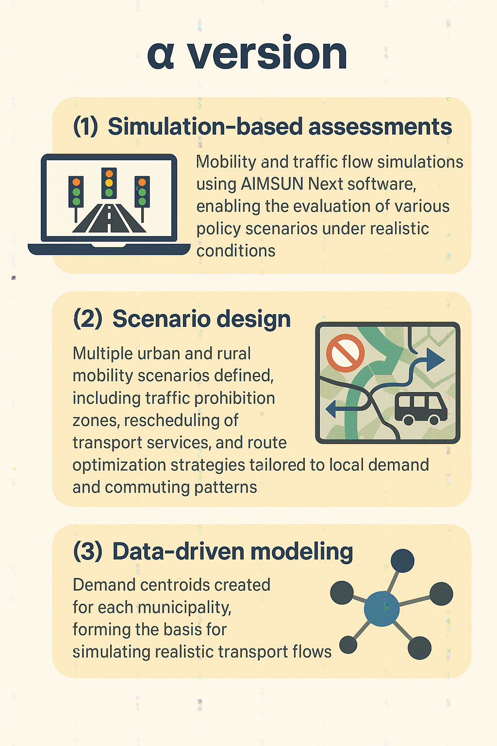
Digital Modelling for Real-World Impact
At the centre of RUE#6 lies the use of AIMSUN Next, a sophisticated transport simulation platform that enables modelling of multiple mobility scenarios under realistic conditions. The software allows planners and engineers to test interventions such as new routes, timetable adjustments, or multi-modal connections before implementation. Through this modelling approach, the RUE evaluates how different measures — such as increased bus frequency, micro-mobility options, or shared transport systems — affect traffic flow, emissions, and accessibility. The results provide evidence to guide policy and infrastructure investment decisions, helping local authorities design transport solutions aligned with sustainability and inclusion goals.
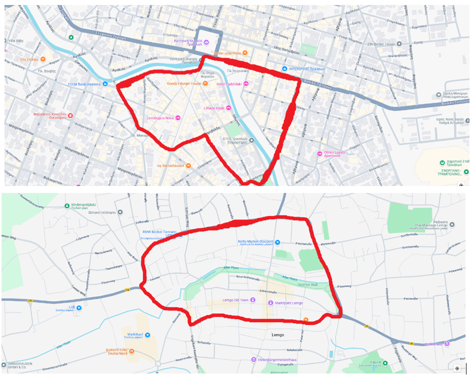
Trikala and Lemgo centres through prohibition for vehicles scenario
From Simulation to Strategy
RUE#6 does not stop at modelling; it transforms technical analysis into strategic mobility planning. By integrating performance indicators on energy use, travel time, and accessibility, the enabler supports decision-makers in developing balanced strategies for rural-urban transport. These strategies can include redesigned public transport routes, park-and-ride options, or improved multimodal hubs connecting rural and peri-urban areas. The approach also places emphasis on inclusiveness and usability, ensuring that proposed solutions consider the needs of different population groups — commuters, residents, and vulnerable users alike. Through iterative testing and feedback, the simulation data are refined into practical insights, producing maps, charts, and dashboards that illustrate the benefits of alternative mobility scenarios.
alpha version of the RUE
Collaborative Design and Local Integration
In keeping with RURBANIVE’s co-creation philosophy, the RUE is developed through close collaboration between the technical partners and municipal actors in Trikala and Lemgo. Each location offers a complementary context. In Trikala, the RUE benefits from the city’s established ecosystem of digital innovation and citizen-centered services. As Greece’s first officially recognized smart city, Trikala has developed a robust framework for e-governance, open data management, and smart mobility solutions. The municipality collaborates closely with e-Trikala S.A., a pioneering public company that integrates technology into everyday urban life. Through this ecosystem, the RUE gains access to valuable experience in digital transformation, stakeholder engagement, and the integration of mobility solutions into a real urban context. In Lemgo, the RUE is located at the Innovation Campus e.V. (ICL), whose campus is home to numerous stakeholders and experts from science, business, and administration. These include schoolchildren, students, employees, and experts in the field of mobility. The campus is home to, for example, the Lemgo Digital smart city living lab, the MONOCAB project, and, in the near future, the Urban Land mobility center. The ICL maintains close contact with these stakeholders, collects practical data, and explores their needs to incorporate them into the work of the RUE. These contexts enable the RUE to validate its models under real operational conditions, ensuring that outputs are both replicable and grounded in local realities.
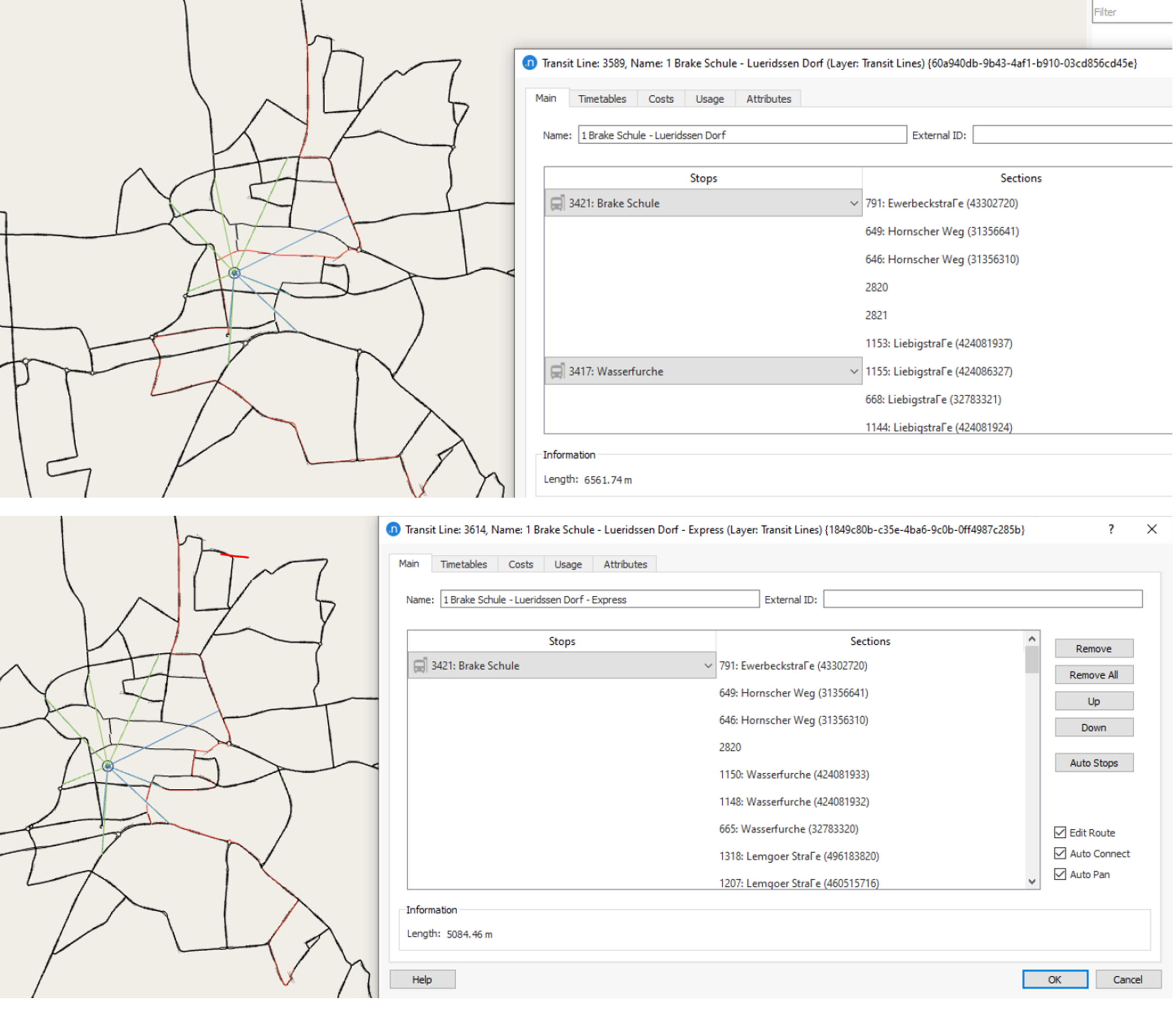
An original route, and a more direct alternative for the same one, for Lemgo
Expected Outcomes and Impact
RUE#6 will result in a validated digital framework for sustainable mobility planning with the following characteristics:
Scenario-based transport simulations for rural-urban corridors.
Data-driven performance indicators supporting policy and design decisions.
Integrated visual dashboards for communicating results to planners and citizens.
Replicable methodology adaptable to other European municipalities.
Demonstrated benefits in emissions reduction, accessibility, and quality of life.
Through these outcomes, the RUE demonstrates how digital intelligence can turn abstract sustainability goals into measurable improvements in daily life — reducing distance not only in kilometres, but in opportunity.
Integration within RURBANIVE
The RUE’s results feed directly into the RURBANIVE Community Store, where its datasets, visual tools, and methodological resources will be available for other regions seeking to modernise their mobility systems. It also provides an operational model for Open Call projects focused on digital and environmental transition. By merging advanced analytics with participatory planning, RUE#6 reimagines mobility as a bridge — connecting territories, people, and the future of sustainable living.